Earthquakes in Jerusalem: A Historical and Seismological Perspective
Earthquakes in Jerusalem: A Historical and Seismological Perspective
Introduction
 |
| The destruction in Jerusalem from the earthquake that occurred in 1927 |
Historical Earthquakes and Their
Impact
Seismic Activity in the Region
Zohar et al. (2016) identified that
54 settlements in Israel and its surroundings were affected by earthquakes at
least twice in the last 2000 years. Jerusalem has the highest number of
documented incidents, with at least 14 occurrences (Zohar et al., 2017). The most
destructive earthquake in recent history occurred in 1927, with a magnitude of
M=6.25, centered near the northern Dead Sea. This event caused significant
damage across the region, with hundreds of casualties and injuries. In
Jerusalem, notable damage was reported in areas such as the Bukharan Quarter,
Mahane Yehuda, Jaffa Gate, the Armenian Quarter, the Old City, Hebrew
University, the Governor's House, Talpiot, and other locations (Avni, 1999).
Importance of Studying Historical Earthquakes
 |
| The epicenters of the earthquakes, intensity and year |
Get Paid To Use Facebook, Twitter and YouTube
Research Objectives
Given the extensive material and
evidence accumulated regarding historical earthquakes that affected Jerusalem,
it is an appropriate target for such research. In this context, the following
research questions are raised:
1. What are the
spatial and temporal damage patterns from earthquakes in Jerusalem and its
surroundings over the last two thousand years?
2. What is the
cumulative chronological damage profile of selected buildings and sites across
the city and its surroundings? The aim is to identify specific buildings or
sites that have been damaged multiple times.
Data Collection and GIS Analysis
The study involved the
interpretation of sources and literature, archaeological findings, precise
mapping of damage, and GIS-based analysis to identify areas with high risk.
Sources included literary documents, historical records, and archaeological
reports. The reliability of these sources was carefully evaluated to ensure
accurate representation of seismic events. GIS technology enabled detailed
mapping and analysis of damage distribution, helping to identify patterns and
high-risk areas.
Findings
Temporal and Spatial Damage
Distribution
The study found that Jerusalem has
been affected by 16 different earthquakes over the past 2000 years. Sites
within the city experienced damage between one and five times during this
period. The highest intensity recorded was 9 on the EMS-98 scale, indicating
relatively moderate damage. The spatial distribution of seismic intensities was
uneven: southeastern areas experienced higher average intensities compared to
western areas.
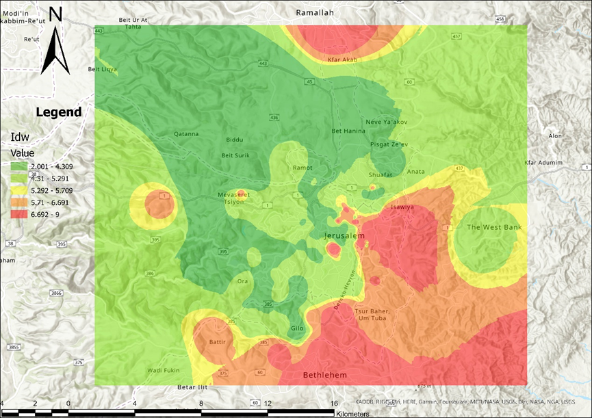 |
| The different impact strengths |
The highest data density was found
in the central research area, around the Old City. This can be attributed to
the concentration of historical and archaeological sites, greater accessibility
for researchers, and a wealth of historical documentation. Sensitive areas to
seismic intensity were identified as the geological formations of Shabta and
Netzer, which showed higher seismic intensities, while the Veredim formation
exhibited greater resilience.
Discussion and Conclusions
Impact of Geological Formations
The varying seismic intensities
observed are linked to the distance from the epicenter and the strength of the
earthquake. Shabta and Netzer formations displayed higher intensities due to
differences in rock structure and lithological characteristics. Conversely, the
Veredim formation showed lower intensities, likely due to its structural
properties that reduce seismic wave amplitudes.
Seismic Intensity Gaps
The study observed gaps in seismic
intensity data, particularly for the first millennium CE. This indicates the
existence of additional earthquakes for which there is no archaeological or
historical evidence, suggesting the need for further research.
Recommendations for Further Research
To fill these gaps, it is recommended
to:
1. Continue
archaeological excavations in underexplored areas.
2. Re-examine
historical documents for additional evidence.
3. Use advanced
technologies such as seismic imaging to identify subsurface structures
indicative of past earthquakes.
Get Paid To Use Facebook, Twitter and YouTube
Summary
Jerusalem has experienced numerous
earthquakes over the past 2000 years, with relatively moderate seismic
intensities. The study highlights the importance of geological formations in
determining seismic vulnerability and emphasizes the need for further research
to fill historical data gaps. Understanding the impact of geological formations
on seismic intensities is crucial for future preparedness and the resilience of
new structures in the area.
Did you enjoy the article? If so, please support the blog by clicking on an advertisement link, sharing the post, and following us. Thank you! – Almog
References
- Avni, G. (1999). "The Earthquake of 1927 in Jerusalem."
Tel Aviv University Press.
- Garfunkel, Z. (1981). "The Dead Sea Transform and Its
Implications for Geology and Seismicity in the Region." Geological Survey
of Israel.
- Galli, P., & Molin, D. (2014). "Earthquake Damage Patterns
in Rome Over Two Millennia: From Historical to Recent Events." Journal of
Seismology, 18(2), 357-376.
- Killebrew, A. E. (2011). "Biblical Jerusalem: An
Archaeological Assessment." In: The City of David: Revisiting Early
Excavations, New Studies, (pp. 45-78). Jerusalem: Israel Antiquities Authority.
- Zohar, M., Marco, S., & Agnon, A. (2016). "Historical
Earthquakes in Jerusalem: Data Collection and Analysis." Journal of
Archaeological Science, 65, 1-12.
- Zohar, M., Marco, S., & Agnon,
A. (2017). "Seismic Hazard Assessment of Jerusalem." Earthquake
Spectra, 33(4), 2309-2331.


Comments
Post a Comment